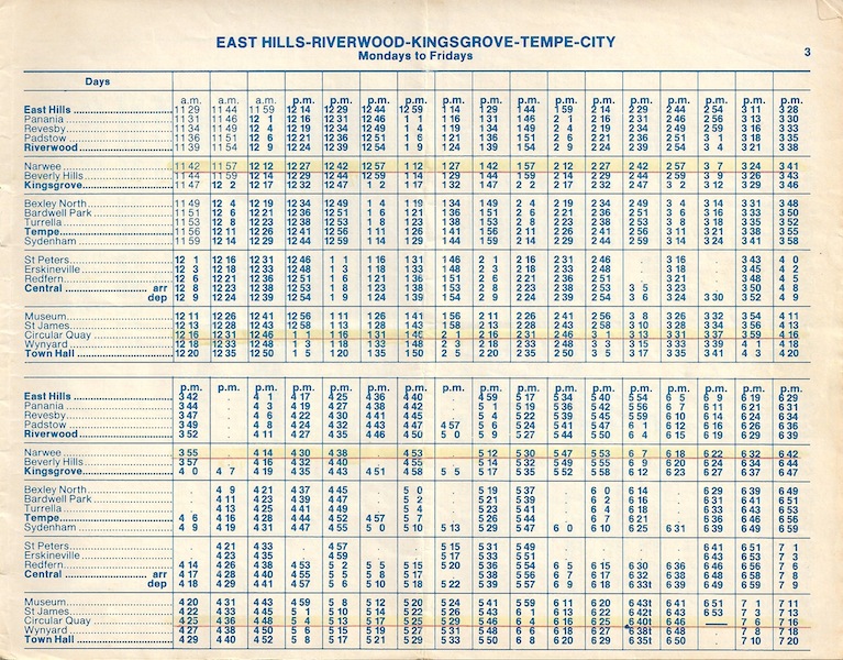
In the last
issue of UNIKEN it was reported that the
University, in a bid to alleviate the student accommodation crisis, intended to
press ahead with plans to build units on two vacant sites at Mulwarree and
Prince Streets, near the Kensington campus. These sites are part of the old
tramway route to Randwick and Coogee and supporters of light rail want to
retain them as a corridor for their proposed scheme.
UNSW is planning to build on a section of the old tramway corridor, which it owns (Prince and Mulwarree Streets). This development will provide needed accommodation for University students; however, due to lack of foresight in
the design of the buildings, the development is currently irreconcilable with a plan for a light rail system
which could use the old tram reservations to reach Randwick and Coogee.
Building on the transport corridor may prove to be
the single most important factor that will condemn UNSW students and staff to
reliance on rubber tubes and the internal combustion engine for their commuting
needs to the University. The
main campus of the University of NSW is located on the eastern seaboard of
Sydney, away from the population and growth centres of Sydney.
It is possible that the lack of easy accessibility
of this campus by public transport will adversely affect our competitiveness
for both students and staff. The University will be the .principal beneficiary of a light rail development in
the Eastern Suburbs (served by the Anzac Parade and Coogee lines) and therefore
it should look at its long term interests and should not rush to build an uncompromising
structure that block the corridor. The
University can build accommodation for 230 students on the Mulwarree site
without affecting the light rail route, by simple rearranging the wings of the
proposed buildings. The proposed development for 90 beds on Prince Street can
only be reconciled with light rail if it
allows the ground floor to be converted to light rail corridor. If this
proves too expensive, the University could delay the Prince Street development
until the prospects of light rail for Sydney are clarified over the next few
years.
The Property and Works Department currently gives
as an excuse for their uncompromising stand the possibility of light rail
following the Alison Road route. Unfortunately, on Alison Road light rail will
have to phase in with cars (one of the reasons for removing the trams in the
first place was that they interfered with cars) and will no longer travel
through a dense residential development.
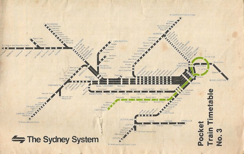
Here I wish to describe a proposal for light rail
in the South-Eastern suburbs of Sydney and then a mirror image of this system
for the Northern and North-Westem suburbs. The multiple interfaces between the
light rail and heavy rail systems displayed in the accompanying map indicate
that our University will be significantly better accessible by public transport
from nearly all areas of Sydney and surrounding towns. The present proposal
shows how this system will service the airport better than the expensive ($200 million) dedicated heavy rail
line from Central Station to the airport. Finally, it shows how this North to
South axis will relieve pressure at Wynyard and Town Hall and will thus
diminish the need for the expensive $350 million "Metro West proposal." While only the South-Eastern
suburbs proposal has been costed at some detail ($100 million, including the
airport link), it is expected that the whole of the proposed scheme for Sydney
will cost less than $550 million (the aggregate cost of the heavy rail link to
the airport and the Metro West project).
Light rail is enjoying expansion around the world at an unprecedented rate. According to the International Union of Public Transport it is now the fastest growing form of tracked transport in the world. In the UK 48 cities
are considering the introduction or have
already introduced light rail. In California,
light rail systems have been introduced
in San Diego, Los Angeles, San
Jose and Sacramento. Here in Australia, Adelaide has
had one light rail line to Glenelg for
decades and
more recently Melbourne has converted two lightly patronised rail services from St Kilda and South Melbourne to light rail.
However, it is here in Sydney where light rail has its greatest potential. This
is because Sydney has the rights of way and the potential passenger volumes for
a highly successful light rail system. As all transport operators know only too well, it is volume that counts when it comes to
providing public transport. Higher density of development and the concentration of high traffic
generating establishments, especially offices, shops, universities and hospitals enable better public transport to be provided
and the better it is, the more people will find it
an acceptable alternative to driving a car.
Potential for Light Rail in Sydney
Sydney is in a unique position to introduce light rail now. In the South Eastern suburbs there are some 15 kilometres of former tramway reservations which serve some of the most densely populated suburbs in Sydney as well as the airport, University of NSW, hospitals,
racecourse and southern beaches. In addition, there is an unused tunnel almost
a kilometre long that runs north/south through the city under Macquarie Street
and Hyde Park. This tunnel includes the unused station platforms at St James.
And there is the former Randwick tramway workshops site ideally placed as a
workshop and running shed for a 25km light rail system in Sydney's
south-eastern suburbs. As can be seen from the accompanying map, the
opening of the Harbour Tunnel next year presents a one-off opportunity to regain
the former tramway across the Harbour Bridge and link this to the south-eastern suburbs network. This route,
connecting as it would the CBD with North Sydney, would become the nucleus of two major light rail corridors north of the harbour. These are: the corridor to
the northern beaches via Mosman and The Spit and the corridor to Western Sydney
(North Sydney, Gore Hill, Ryde, Epping, Carlingford, Parramatta) via the Epping
Highway.
Opening of the
Harbour Tunnel and the Gore Hill Freeway
The opening of the Harbour tunnel provides a convenient goal for
decision making
on the first stage of
the light rail system.
In
conjunction with the tunnel, a new freeway will be opened to Gore Hill where it will link with the Pacific Highway and the Epping Road corridor. In doing so, it will relieve the Pacific Highway from Gore Hill to North Sydney
thereby enabling the provision of an on-street light rail line to serve this major strip of office
employment. Thus, the first stage of a light rail system in Sydney should
capitalise on the current road and tunnel works to get a line from Gore Hill via Crows Nest, North Sydney and the Harbour Bridge, then across to the Conservatorium and a short underground link to the St James tunnels. From here it will proceed to Randwick, where the depot and workshops would be sited, the UNSW and the rest of the South Eastern suburbs.
Servicing the airport and
obviating the need for the Metro West (City) proposal
The light rail system will service the airport
with a direct connection to Sydenham Station and an indirect connection through
Anzac Parade and UNSW to the city and then North Shore. Additional benefits of
this north/south link include the improved access to the eastern side of the
city (viz Martin Place, St James and
Museum) from the North Shore, which is currently only conveniently connected to
Town Hall and Wynyard. The converse movement from Museum, St James and Martin
Place to the North Shore employment areas is even more important because it removes the congestion currently caused by interchanging passengers at Town Hall and Wynyard stations by transferring these movements to St James (where the interchange from the
Bankstown, East Hills and Campbelltown lines would be cross platform) and Martin Place. This objective could defer the need for the very expensive ($350 million) Metro West proposal of the SRA which offers little in the way of transport improvements to the suburbs.
Other opportunities for light rail in Sydney
A number of politicians
and prominent
people in the community have asked why not promote light rail in the Western suburbs where the need for improved public transport is
perceived to be the greatest. The answer to that is twofold: 1) Light rail
transit's viability depends on passenger volume which in turn depends on
relatively high density development; 2) it must be possible to obtain
corridors, where they are needed, cheaply. Unfortunately there is nowhere in
Sydney's West where either, let alone both, of these criteria are met. The
Department of Planning has done some excellent work in preserving the
opportunity for a major transport corridor from Hoxton Park to Parramatta and
on up to the Hills district. This is a very far sighted plan and as Parramatta
develops into a major employment area (like the lower North Shore now) light
rail will become a very real possibility. However,
much of the corridor has yet to be acquired and on the Baulkham Hills leg which
is the most heavily trafficked route at present, leading as it does to the rapidly developing North West sector, land
acquisition costs could be as high as $30 million per kilometre. Current bus
passenger volumes are of the order of 1,000 per hour compared with 5,000 in the
south-eastern suburbs where virtually no property has to be acquired. Further,
the civil engineering formations and drainage patterns for the former tramway
system in the southeast are still intact.
LA versus Sydney
It is coincidental that the last electric line in
what was at one stage a huge rail network in LA was closed down in 1961,the
last year trams ran in Sydney. The last line to close was to Long. Beach. Last August, the Long Beach-Los Angeles line was re-opened at a cost of $900 million (US) for an expected 15/20,000 passengers per day. We estimate our South-eastern
system here in Sydney would carry at least 4 times this number of
passengers at a cost of around $100 million for construction and another $100 million or so for rolling stock (which would probably be leased). John Dunn,
an
international authority on rail car designs, has reported that his overseas colleagues are surprised to learn that Sydney has unused potential public transport corridors and is not establishing a light rail system. Cities overseas use their corridors and attempt to procure more; the irony and anachronism of the situation in Sydney is that the State Transit Authority is now selling both tramway
reservations and tram workshops
in Randwick. Greenpeace (who
has written to UNSW opposing the planned unit development) consider transport
the area where saving in greenhouse gas emissions will cause the least dislocation. Planning for transport is planning for the future of Sydney and assisting in the construction of a sustainable society on the planet. I am not expecting that the University will concern itself with the habitability of the planet. I am suggesting that the self-interest
of the University will be incomparably better served by the light rail system
than by taking full advantage of a segment of the corridor as a building site
at this time.
UNIKEN, 22 March 1991-11